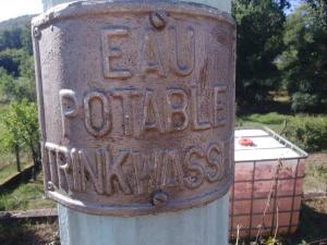
Fontaine (eau potable)
- Description
- Une fontaine le long de la départementale
- Spring or tap water
- Spring water
- Dog bowl
- Unknown
- Bottle refill station
- Yes
- Approved by public authorities
- Yes
- Last approved date
- 21/08/2022
- Country
- France
- Postcode
- 67510
- City
- Niedersteinbach
- Address
- Rue Principale 43
- Nearby cities
-
- Pfaffenhoffen (67350)
- Soultz-sous-Forêts (67250)
- Münchweiler an der Rodalb
- Gundershoffen (67110)
- Mertzwiller (67580)
- Betschdorf (67660)
- Hauenstein
- Lemberg
- Niederbronn-les-Bains (67110)
- Niederbronn-les-Bains (67891 CEDEX)
- GPS coordinates
-
- Latitude
- 49.029645480129
- Longitude
- 7.7170683370094
- Degrees minutes
- N 49° 1.779', E 7° 43.024'
- Submitted by
-
Thierry
- Created date
- 2022-08-21 08:54:16
- Last updated date
- 2022-08-22 08:42:07
Map
Nearby
| Name | Type | City | Distance |
|---|---|---|---|
| Fontaine (eau potable) | Spring | Niedersteinbach | 0 kms |
| Fontaine | Spring | Niedersteinbach | 0 kms |
| Fontaine 2 têtes de Lion | Spring | Obersteinbach | 2 kms |
| Fontaine (centre du village) | Spring | Lembach | 6 kms |
| Fontaine & aire de repos | Spring | Lembach | 6 kms |
| Deux Fontaines | Spring | Lembach | 6 kms |
| Fontaine | Tap | Lembach | 6 kms |
| Source de Mouterhouse | Spring | Mouterhouse | 20 kms |
| Water tap on camping | Tap | Mittelbergheim | 28 kms |
